Why Construction Teams are Combining 3DGS with Traditional GIS
Discover how MipMap bridges this gap by fusing production-grade 2D precision with photorealistic 3DGS. Learn how our browser-based tools eliminate data friction, streamline progress tracking, and elevate remote collaboration directly from your desktop.
Managing a modern construction project is often a constant battle against data silos. At any given moment, project managers, design engineers, and stakeholders all need an accurate, ground-truth understanding of current site conditions. Traditionally, however, this meant sifting through unorganized site photos, cross-referencing tedious spreadsheets, or making frequent, time-consuming site visits. These methods are not only inefficient but also fail to provide teams with an intuitive, unified perspective of reality.
While drone mapping has dramatically expanded data acquisition capabilities, deliverables in practice often remain isolated by format. High-precision 2D maps, such as orthomosaics, excel at planimetric measurements and boundary lines; meanwhile, traditional 3D mesh models serve as the backbone for spatial drafting and elevation analysis due to their rigid geometric topology. Yet, when it comes to high-frequency cross-team collaboration, remote progress updates, and routine inspections by non-survey professionals, engineering teams are routinely bogged down by data conversion and fragmented workflows.
MipMap bridges this gap. As an all-in-one digital platform, MipMap seamlessly fuses production-grade 2D precision with photorealistic 3D environments. Without forcing teams to alter their established habits, it integrates directly into existing industry workflows.
2D Orthomosaics and Compatibility with Traditional GIS Workflows
In civil engineering and surveying, 2D orthomosaics remain the foundational backbone of production-grade workflows. Whether for routine on-site measurements or integration into GIS systems, engineers require standardized, highly compatible map data.
While delivering an immersive 3D experience, MipMap fully supports the processing and distribution of standard 2D deliverables.
Flexible Format Export: Once annotations and measurements are completed within MipMap, users can export this data into standard industry formats tailored to their specific operational needs, ensuring seamless integration with existing daily workflows.
In-Platform Viewing: Beyond data exporting, users can review and retrieve detailed annotation and measurement reports directly within MipMap, eliminating the need to constantly toggle between external viewing utilities and streamlining data review.
Deliverables in these standard formats are routinely imported by engineers into leading Geographic Information Systems like QGIS and ArcGIS to overlay with existing city zoning boundaries, parcel lines, or underground utility maps. They are also widely utilized as foundational layers in CAD and BIM software, providing the most up-to-date and precise as-built context for designing new structures, roadways, or terrain modifications.
3DGS Technology in Reality Capture: Application and Collaboration
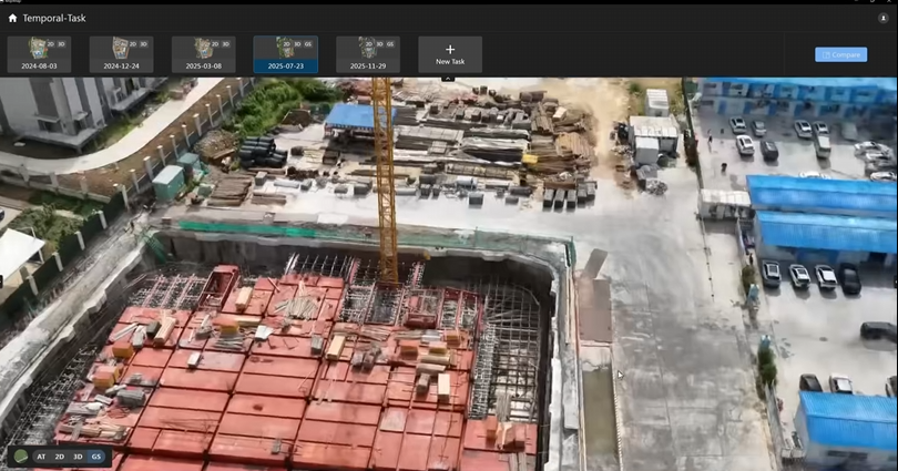
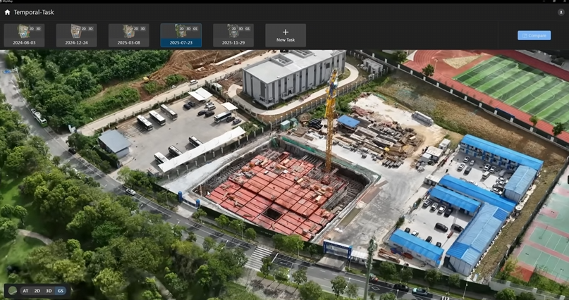
Traditional project updates often leave remote teams and owners relying on dense spreadsheets to track progress or spending hours cross-referencing disjointed site photos to identify field changes—a process that is both inefficient and lacks a comprehensive, intuitive overview. To make every site update immediately recognizable, MipMap introduces 3DGS into the digital twin environment.
Core Deliverables of a 3DGS-Powered Digital Twin
Photorealistic Reality Capture: 3DGS replicates the physical world with photorealistic fidelity. It delivers an intuitive, 360-degree view of construction sites, capturing complex physical details and material textures. Whether mapping intricate structural frameworks or legibility on site signage, the environment maintains stunning clarity, removing the technical barriers to understanding site conditions.
Web-Based Sharing: This technology is highly optimized for standard hardware and network bandwidths, making it incredibly lightweight. Users do not need to download massive files or install heavy, specialized engineering software or plugins. A simple, standard web link allows anyone to instantly and smoothly "fly" into the active site environment from a standard desktop or mobile browser, enabling immediate cross-team collaboration.
Empowering Core Operations: Remote Site Visits
This blend of photorealism and lightweight deployment fundamentally optimizes remote cross-regional communication. Out-of-town investors, owners, and construction managers no longer need to constantly travel to loud, shifting, and potentially hazardous jobsites. Through MipMap's 3DGS digital twin environment, stakeholders can remotely inspect the latest as-is site conditions from any angle right from their screens. This direct visual feedback makes remote progress reviews and stakeholder alignment meetings far more straightforward and efficient.
MipMap Smart Monitoring and Built-In Measurement Tools
While photorealistic 3DGS capturing brings intuitive remote site visits right to your fingertips, MipMap goes a step further when your team needs precise engineering data. Based on high-accuracy 3D mesh models and standard 2D data, our built-in measurement and monitoring tools allow you to analyze the jobsite directly from your browser.
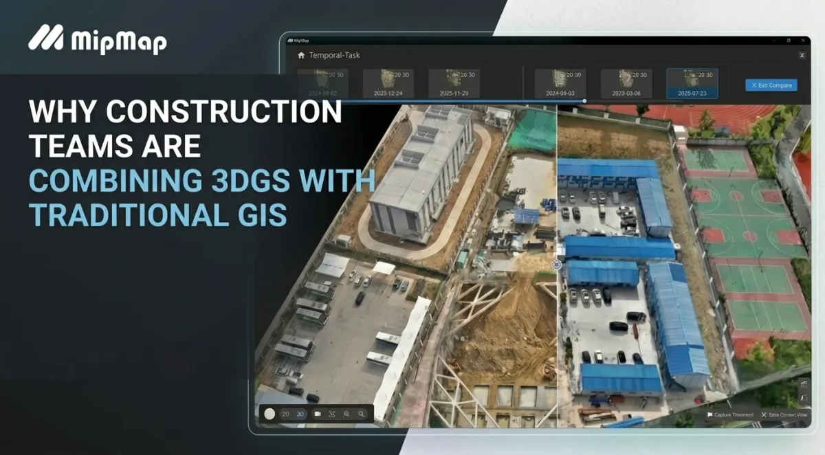
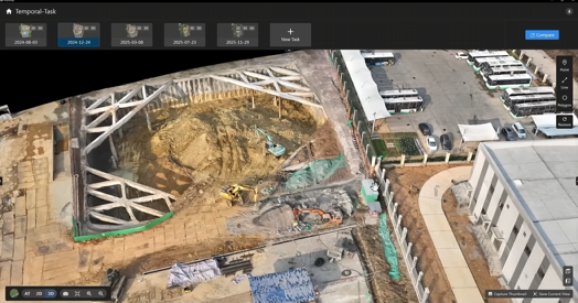
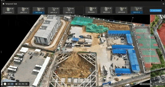
The Swipe Tool: Eliminating the Friction of Progress Tracking
By simply dragging a central slider across the screen, users can leverage the swipe tool to conduct instant, side-by-side comparisons of multi-source data. The tool supports seamless switching and overlaying between the following views:
- 3D reality models from different dates
- High-resolution orthomosaics
- Digital Surface Model (DSM) layers
With this tool, management teams no longer need to toggle between multiple independent rendering windows. Instead, they can intuitively track weekly and monthly project progress within a single interface, instantly capturing every physical change on site.
Browser-Based Measurements: Simplifying Initial Quantity Takeoffs
Within MipMap's digital twin environment, complex surveying takeoffs and critical asset tracking are streamlined into straightforward, online actions. Any authorized user can perform the following tasks directly in their web browser:
- Linear Measurements: Instantly capture the exact distance between any two points on site.
- Area Calculations: Quickly draw a bounding polygon to automatically calculate the square footage of specific work zones.
- Tagging Specific Areas (POI): Drop custom digital pins on critical equipment, materials, or covered utilities, ensuring clear and precise guidance for cross-team collaboration.
All measurement and annotation data can be retrieved at any time or flexibly exported into standard industry formats based on your specific team requirements.
Volumetric Reports: Streamlining Earthworks and Stockpile Audits
Building upon its existing planimetric and linear toolsets, MipMap is continuously iterating with advanced capabilities like volumetric measurements. This upcoming feature will significantly expand the software's utility on active jobsites. Teams will be able to calculate earthwork volumes and measure material stockpiles directly within the digital twin environment. This makes complex volumetric verification effortless and provides a highly visual, objective data baseline for routine coordination between general contractors and subcontractors.
Driving Cross-Team Collaboration Efficiency
In modern construction management, the true value of digital tools lies not in replacing mature, existing workflows, but in accelerating data mobility and collaboration across teams.
By uniting production-grade 2D spatial data with photorealistic 3D reality capture in a single environment, MipMap enables users to seamlessly embed up-to-date site data into their daily routines. Ultimately, MipMap is dedicated to making cross-regional communication simpler, more intuitive, and highly efficient.
If you are looking for a more intuitive way to collaborate on site progress, visit our official website to discover how MipMap can help your team manage jobsites efficiently right from your desktop.
Learn more 👉 https://na.mipmap3d.com/
See how to capture data with drones 👉 https://na.mipmap3d.com/blogs/from-field-to-model-capturing-high-quality-3d-gaussian-splats-with-uav-imagery/